Wake turbulence is invisible, extremely powerful and can last for several minutes, making it important to take note where the turbulence likely is, and time until it’s likely dissipated, or plan to fly over it instead of through it.
In this video, a UH-60 Blackhawk helicopter takes off, and only 27 seconds later, a Cirrus SR-20 attempts to land. The airplane appears to fly into the area where rotor wash was produced with disastrous results.
This accident happened in Fort Collins, Colorado. It’s reported that the pilot was only on his second solo in the Cirrus, and attempted to land long after he saw the helicopter take off. The rotor wash the airplane flew into put the plane into a steep left bank which was impossible to recover from since it was only a few feet from the ground.
How helicopters produce rotor wash
Helicopters produce rotor wash much in the same way that fixed wing aircraft produce wake turbulence. The lift produced by the rotors create vortices that swirl downward, bounce off the ground and go up again. If winds are light, as they were in this scenario, the turbulence will linger a lot longer. In this situation, the pilot of the Cirrus hits the turbulence 27 seconds after the helicopter took off.
On takeoff, rotor wash is harder to manage. If the pilot was taking off, the pilot would have to plan to have taken off well beyond the point where rotor wash is suspected, and to have climbed enough to avoid it, much like an obstacle take off.
How to avoid rotor wash
Again, these procedures are similar to avoiding wake turbulence. Stay above rotor wash, know the direction the wash will travel due to winds. Stay upwind of the wash and give it several minutes to fully dissipate. Stay above and land beyond where the turbulence is. In this situation, the pilot should have either have tried to land long or just execute a overshoot.
In a controlled airport, air traffic control will help you avoid the wash, but if you’re in an uncontrolled aerodrome, you’ll have to be extra vigilant.
The highly anticipated NextGen area navigation, a type of RNAV equipment is now available at At Dallas / Fort Worth International Airport (DFW). It has been very successful, allowing the airport to accommodate practically a tripling in departures. In fact, NextGen satellite procedures allow for a 15-20% increase in departures per hour in congested periods.
What is RNAV?
RNAV is area navigation, which allows IFR aircraft to choose any route between a network of navigational beacons for route finding. Rather than flying from beacon to beacon, aircraft can fly any route within the coverage of station-referenced navigation signals. This allows lots of flexibility since aircraft can fly a straight course rather than zigzagging to and from beacons. The beacons are satellite serviced.
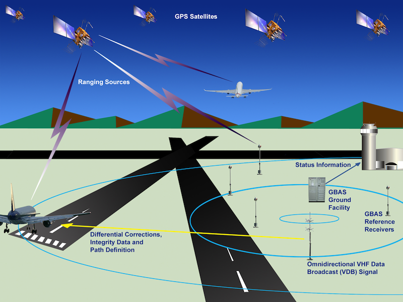
Ground based RNAV is serviced by satellites and onboard technology. Image from faa.gov.
RNAV was introduced in the 1960’s and slowly waned in popularity as airlines began to favour inertial navigation systems rather than ground based navigation aids. RNAV was re-introduced after the massive introduction of satellite navigation. The procedure uses a combination of onboard equipment and satellites to ensure that aircraft follow a precise path and heading. Conventional RNAV procedures begin only once the aircraft is airborne, while ground based RNAV, such as the one at DFW, begins on the runway.
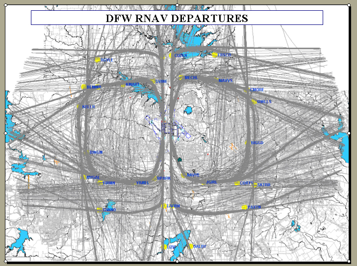
RNAV departures at DFW. DFW is the fourth busiest airport in the world by aircraft movements. Image courtesy of Boeing.com
How does NextGen work?
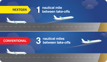
NextGen starts working on the ground and only requires one nautical mile between departing aircraft. This system begins service on the runway and is provided to the aircraft as it enters high altitude airspace.
Conventional departure procedures, which require more correspondence between the pilots and ATC, call for separation minimums with departing aircraft of 3 nautical miles between take-offs. Those two miles make a difference. American Airlines, who is responsible for 80 per cent of DFW departures, has already reported an increase in throughput of between 10 – 20%.
Most aircraft use RNAV when they are in the air, however the difference at DFW is that RNAV navigation starts on the runway – on the ground, and not in the air. Hence separation is provided before takeoff allows smaller separation minimums to be observed.
In a congested airport like DFW, this really does make a difference. Less aircraft idling and waiting means fuel savings. Approximately 95% of the commercial jet fleet at DFW is equipped to fly RNAV. DFW is one busy airport – as you can see in the image above. In fact, it is number four in the world for aircraft movements, tallying 650,124 movements in 2012.
What are the benefits?
RNAV allows to conserve flight distance, save fuel, reduce congestion as well as allow flights into airports without beacons. RNAV beginning on the runway offers more time and fuel savings, for example, American Airlines has reported an annual fuel savings of around $10-12 million at DFW due to these improved RNAV technology. This will also improve local air quality.
Reduces possibility of verbal communication error
Since RNAV provides a pre-determined flight track programmed in the aircraft’s flight management system, this means less communication with pilots and ground controllers. This is more expeditious than the regular procedure, in which the controller gives the pilot a heading and the pilot will acknowledge it verbally. This gives less chance for a miscommunication to happen, and the FAA reports it has already decreased pilot-controller verbal correspondence by over one third. This gives controllers more time to concentrate on traffic that requires more complicated instructions.
This is a very popular technology that will likely be introduced at many congested airports worldwide.
I am currently studying air law. Air law is a big topic and will take some time to cover. It’s hard to present all this information, so I thought I’d review a few of the very basics.
Material for air law is found in the Canadian Aviation Regulations (CARS). CARS is divided into two parts, the Regulations, which provide the rules, and the Standards, which give us guidance on how to apply the rules. There are eight parts, or subject areas:
Part 1 General Provisions
Part 2 Aircraft Identification and Registration
Part 3 Aerodromes and Airports
Part 4 Personnel Licensing and Training
Part 5 Airworthiness
Part 6 General Operating and Flight Rules
Part 7 Commercial Air Services
Part 8 Air Navigation Services
Canadian Airspace – Image from Transport Canada (tc.gc.ca)
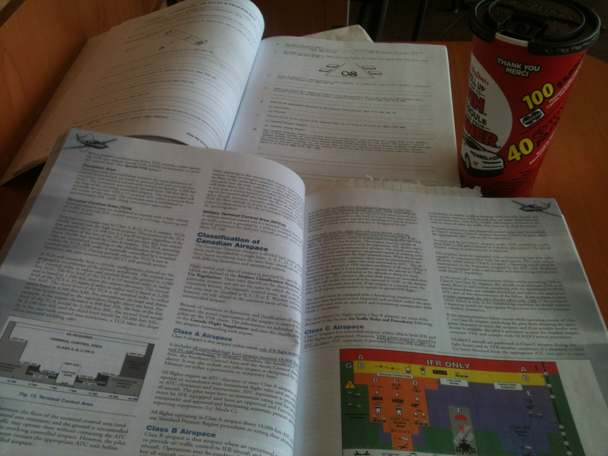
In Canada, airspace is divided into Northern Domestic Airspace (NDA) and Southern Domestic Airspace (SDA). The NDA runs in close proximity to the earth’s pole, and the lines of force dip towards the pole make the compass reading unreliable, because the compass lies in a horizontal plane. Therefore, aircraft operating in this zone must fly according to true track calculations. Runway numbering is oriented to and surface winds are provided in degrees true. At night or IFR aircraft must be equipped with a gyroscopic direction indicator.
Runway numbering
In SDA, aircraft operate according to their magnetic track. Runways are numbered according to their magnetic track, and surface winds are also reported in degrees magnetic. Runway markings are numbered to the nearest 10 degree increment, and the last digit is dropped. For example, runway with the heading 163 will be abbreviated 16.
Altimeter Regions
Canada is also divided into an altimeter setting region and a standard pressure region. The limits of the altimeter setting region are the same as for the SDA and vertically below FL180 (flight level 18,000 feet). In this region, a pilot must set their altimeter to the current altimeter reading for the departing airport and airports along the flight. The standard pressure region encompasses the NDA and anywhere above FL180. The altimeter is set to standard sea level pressure (29.92″ Hg). For takeoff and climb for an airport in this region, altimeter should be set to the setting for that particular airport, and reset to standard pressure upon reaching cruising altitude. For descent and landing, the altimeter setting for that particular airport should be set.
Uncontrolled Airspace
This consists of airspace where there is no air traffic control (ATC). Because of this, aircraft in close proximity may present a hazard since to monitoring is given, hence pilots are required to monitor the frequency 126.7 continuously broadcast their location, altitude and intention.
Controlled Airspace
Here ATC is provided and consists of high level (above FL180) and low level airspace (below FL180).
High Level Airspace
All airspace above 18,000. This is divided into three regions: (1) Southern Control Area (SCA): same boundaries as SDA, within this area, all traffic (above 18,000 feet) is controlled, the (2) Northern Control Area (NCA) which extends from the northern limits of the SCA to about 72 degrees latitude, and all traffic above FL230 is controlled, and the Arctic Control Area (ACA) which extends from the boundary of the NCA to the North Pole. It controls all the airspace above FL270.
High level airspace includes high level airways which are prescribed tracks between specific navigation aids where ATC is provided, and high level air routes which are the same as airways but no ATC is provided.
Low Level Airspace
This is Canadian Domestic Airspace below 18,000 feet ASL, not all of which is controlled. Controlled low level airspace includes
Low level airways: routes which aircraft can navigate by following a non directional beacon, and VHF/UHF airways spaced approximately 100 miles apart along the airway. The basic width is 4 nautical miles on each side. Low Frequency/Medium frequency airways (LF/MF) are navigated with reference to signals from low frequency transmitters. The width is 4.34 nautical miles on each side. An airway has it’s base at 2,200 AGL and extends up to the base of the overlying high level airspace.
Control Area Extensions (CAE): are additional control zones established at some busy airports within controlled airspace to handle IFR traffic. They extend from 2,200 to 18,000 ‘ AGL.
Control Zones: Designated around certain aerodromes to monitor IFR traffic and facilitate the movement of IFR and VFR traffic. The upper limit is usually 3000′ AGL. They can be classified as B,C,D or E depending on the classification of surrounding airspace. Most with terminal control have a 7 nautical mile radius, others 5, and a few only 3.
Canadian Terminal Control Area (TCA) Airspace. Figure from Transport Canada (tc.gc.ca)
Terminal Control Areas (TCU): These are established at airports with heavy traffic to provide IFR service to aircraft. They may be A, B, C, D or E and usually extend into high level airspace. The TCU takes the shape on an inverted wedding cake. The limits are specified on the figure to the left.
Next, I’ll review the Classification of Canadian Airspace – airspace classes, A, B, C, D, E, F and G. Read more air law here.
Flying out CYBW, Springbank airport which is number 6 for aircraft movements in Canada. We live near the rocky mountains of Alberta and are obsessed with mountains and aviation!
>>Read More >> Contact me
")
 Airspace. Figure from Transport Canada (tc.gc.ca)")
